
Location Map For Centerville
| Year | Population |
|---|---|
| 1970 | 19 |
| 1980 | 28 |
| 1990 | 30 |
| 2000 | 26 |
| 2010 | n.a. |
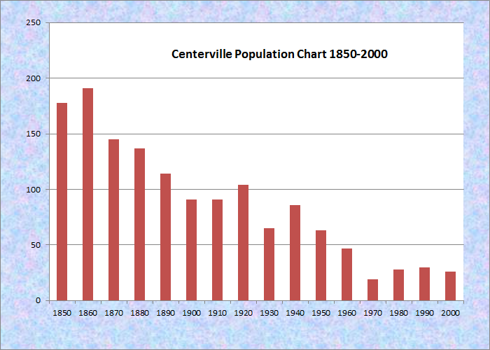
Population Trend 1850-2000
| Geographic Data | |
|---|---|
| N. Latitude | 44:45:53 |
| W. Longitude | 67:37:12 |
| Maine House | District 30 |
| Maine Senate | District 22 |
| Congress | District 2 |
| Area sq. mi. | (total) 43.0 |
| Area sq. mi. | (land) 41.9 |
| Population/sq.mi. (2000 Census) | (land) 0.6 |
County: Washington
Total=land+water; Land=land only |
|
[CEN-ter-vil] was a town in Washington County, incorporated on March 16, 1842 from township T23 ED.
It was named to note its central location (at least on the east-west axis) in the County.
In 1886 it had a rail freight connection, now a recreational trail, with Machias. The economy was based on two shingle mills, potatoes and hay.
In 1870 its population stood at 145; by 1880 it had plunged to 32, from which level it apparently never recovered.
Centerville had been the town with the smallest population in the state according to the 2000 census. It is now an unorganized township, having been dissolved as a town on July 1, 2004.
It has no State Route highways and only a few miles of paved roads.
Its small village is in the western edge of the township on Centerville Road. The Machias River covers the eastern end as it moves south through the town of Machias, then to Machias Bay and the Gulf of Maine.
Additional resources
Varney, George J. A Gazetteer of the State of Maine. 1881. p. 169.