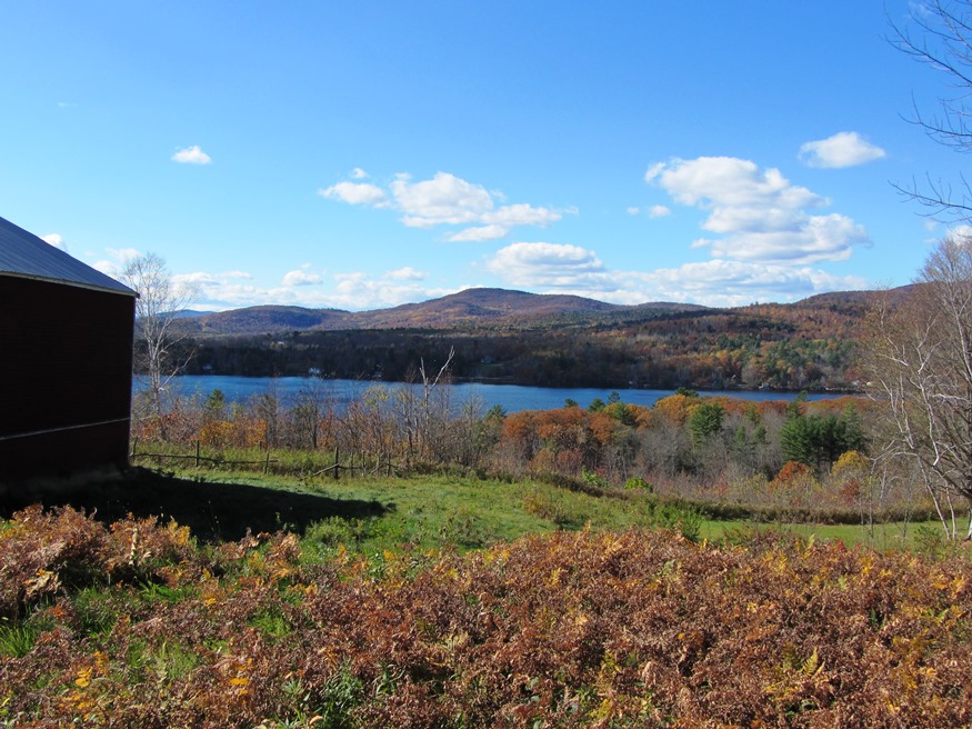
Lake Anasagunticook from Staples Hill Road in Canton (2013)

Location Map For Canton
| Year | Population |
|---|---|
| 1970 | 742 |
| 1980 | 831 |
| 1990 | 951 |
| 2000 | 1,121 |
| 2010 | 990 |
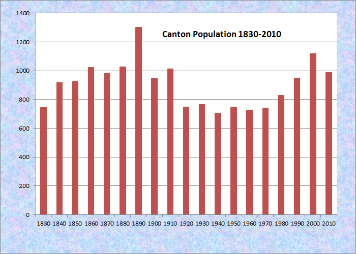
Population Trend 1830-2010
| Geographic Data | |
|---|---|
| N. Latitude | 44:28:17 |
| W. Longitude | 70:18:03 |
| Maine House | District 116 |
| Maine Senate | District 18 |
| Congress | District 2 |
| Area sq. mi. | (total) 30.3 |
| Area sq. mi. | (land) 28.9 |
| Population/sq.mi. | (land) 34.3 |
County: Oxford
Total=land+water; Land=land only |
|
[KAN-tun] is a town in Oxford County, incorporated on February 5, 1821 from a portion of Jay. In the following decades it ceded land to Jay (1824, 1831) and Peru (1859), and annexed land from Hartford (1838, 1839, 1850).
 N44° 26' 21.52\" W70° 18' 47.77\"")
Historical Society (2013) @
 N44° 26' 21.88\" W70° 18' 48.32\"")
Masonic Building (2013) @
The main village overlooks Lake Anasagunticook at the junction of Routes 108 and 140. The Androscoggin River winds through the middle of the town just north of Canton village.
 N44° 26' 30.06\" W70° 18' 58.61\"")
Gazebo in the Village (’13) @
 N44° 26' 34.48\" W70° 18' 58.93\"")
United Baptist Church (’13)
Canton was home to Cornelius Holland who practiced medicine and farmed the area. He was elected to the legislature and to Congress in the early 19th century. John Philip Swasey, another member of Congress and a state legislator, was born here in 1839.
In 1886, George Varney in his Gazetteer observed
A fine water-power on the outlet near the [Whitney] pond is Canton village and post office. Here are Canton Mills, consisting of a saw-mill manufacturing short lumber, a shook and stave mill, and a grist mill. Other manufactures are the steam mill of the Canton Steam Mill Company, a carriage and zinc wash-board factory, a foundry, a furniture and moulding factory, a tannery and several small establishments. . . . The population in 1870 was 984. In 1880 it was 1,030.
N44° 26' 11.19\" W70° 18' 32.53\"")
Fire and Highway Departments (2013) @

Pleasant Street, postcard c. 1905
This attractive community grew in population by nearly 18 percent in the 1990-2000 decade, but lost some by 2010. Essentially the population reflects the level of the late 19th century Canton.
 N44° 28' 15.62\" W70° 19' 30.46\"")
Farmhouse and Field (’13) @
 N44° 27' 48.50\" W70° 19' 16.58\"")
Cornfield in Fall Foliage @
 N44° 28' 14.92\" W70° 19' 29.96\"")
Cornfield in Fall Foliage @
Photos above were taken on Route 108 north of the village in 2013. The Thorne Mountain Road leads to a trail that follows the east side of the mountain to Bonney Road, which then leads to Route 140 on the north shore of Lake Anasagunticook.
Form of Government: Town Meeting-Select Board.
More Videos!
Additional resources
Canton (Me.) Records, 1829-1916. Cataloger Note: A collection of town records of Canton, Maine. Included is a ledger dated 1842 listing taxes assessed . . . [and] a small collection of records from the selectmen’s office from 1829 to 1868 . . . .
Dalton, Pete. They Heard the Call: Contributions of Five Maine Towns in the Civil War. Union, Me. Union Pub. Co. 1995.
Varney, George J. A Gazetteer of the State of Maine. 1886. pp. 157-158.
Vashaw, Norman A. What Was Ain’t What Is: a Picture History of Canton, Maine. Norm Vashaw & Bob Barrett. 1995. (Canton, Me. Country Press Printing)