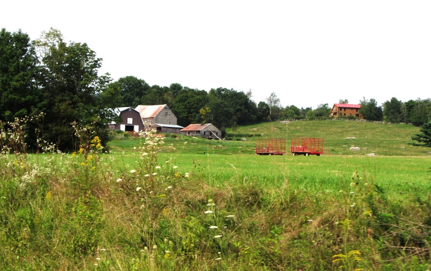
Farm in Buckfield on Route 117, Roundabout Road (2013)

Location Map For Buckfield
| Year | Population |
|---|---|
| 1970 | 929 |
| 1980 | 1,333 |
| 1990 | 1,566 |
| 2000 | 1,723 |
| 2010 | 2,009 |
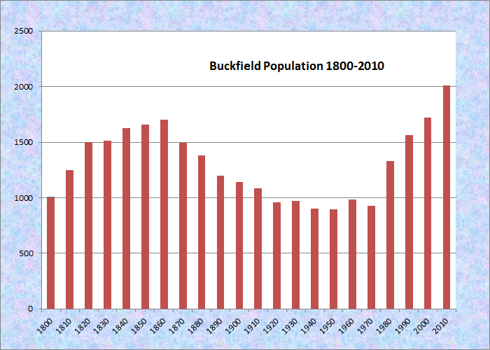
Population Trend 1800-2010
| Geographic Data | |
|---|---|
| N. Latitude | 43:56:06 |
| W. Longitude | 70:55:12 |
| Maine House | District 73 |
| Maine Senate | District 18 |
| Congress | District 2 |
| Area sq. mi. | (total) 37.9 |
| Area sq. mi. | (land) 37.7 |
| Population/sq.mi. | (land) 53.3 |
County: Oxford
Total=land+water; Land=land only |
|
[BUK-field] is a town in Oxford County, incorporated on March 16, 1793 from Bucktown Plantation, also known as Plantation Number 5. According to the Town Report of 1977, the first settlers were Nathaniel Buck, presumably the town’s namesake, Benjamin Spaulding, Simon Record, and Thomas Allen.
 N44° 17' 25.02\" W70° 21' 55.52\"")
Village Center (2013) @
 N44° 17' 23.01\" W70° 21' 55.55\"")
Village Shops (2013) @
 N44° 17' 22.50\" W70° 21' 53.09\"")
Tilton’s Market (2013) @
 N44° 17' 22.50\" W70° 21' 53.09\"")
Library&Veterans Memorial @
Virgil Delphini Parris was born in Buckfield in 1807, attended law school, and began his practice here in 1830. Two years later he was elected to the Maine House of Representatives, and in 1837 was elected to the U.S. Congress. He was the cousin of governor and Congress member Albion K. Parris from the neighboring town of Hebron.
The 1886 Gazetteer of Maine notes
The Buckfield and Rumford Railroad passes through the the town in a nearly north and south course, having a station at Buckfield Village.
. . . .
The manufactures of the town are long lumber, shingles, staves, box-boards, flour and meal, shovel-handles, hand-sleds, drag-rakes, brushes and brush blocks, powder-keags, leather, harnesses, cutting-blocks, men’s boots, etc. Buckfield Village is the principal centre, not only for this but for several adjacent towns.

1881 Roundabout Bridge*
The picturesque, but apparently inadequate, 1881 Roundabout Bridge, over the Nezinscot River, was replaced in 1977 by the standard steel structure found throughout the state. The river is sometimes the choice for people seeking a scenic, moderately challenging canoe trip from Buckfield to Turner. The Bridge House in the village hugs the right bank, with rapids above and flat water below the nearby bridge.
 N44° 17' 23.78\" W70° 21' 55.56\"")
Nezinscot River (2013) @
 N44° 17' 23.40\" W70° 21' 55.60\"")
“The Bridge House” (2013) @
 N44° 17' 24.19\" W70° 21' 55.42\"")
Nezinscot River (2013) @
Buckfield village is compact, having within a few hundred yards of its center the public library, two veterans memorials, the Masonic Temple, the Odd Fellows Building and Theater, the Post Office, and a general store. A short distance away is the Community Church, the Community Center and Town Offices, and the Fire Department.
 N44° 17' 25.06\" W70° 21' 55.32\"")
Masonic Temple (2013) @
 N44° 17' 21.86\" W70° 21' 51.42\"")
Odd Fellows Building (2013) @
 N44° 17' 21.90\" W70° 21' 52.86\"")
Post Office (2013) @
 N44° 17' 18.55\" W70° 21' 44.57\"")
Community Church (2013) @
 N44° 17' 24.56\" W70° 21' 55.17\"")
Houses in the Village (2013) @
 N44° 17' 18.56\" W70° 21' 44.73\"")
Community Center (2013) @
 N44° 17' 17.91\" W70° 21' 44.87\"")
Fire Department (2013) @
 N44° 17' 55.13\" W70° 21' 36.11\"")
Jr/Sr High School (2013) @
Buckfield is home to Wells Wood Turning & Finishing, a firm that has supplied the White House annual Easter Egg Roll with thousands of colorful souvenir wooden eggs, one for each participating child.
 N44° 16' 31.09\" W70° 19' 53.30\"")
Classic Brick House, Turner Street (2013) @
 N44° 17' 38.87\" W70° 21' 33.87\"")
American Legion Post (2013) @
This apple growing community lies at the junction of the east and west branches of the Nezinscot River between Turner and South Paris on Maine Route 117. Gain an insight to the community’s issues by viewing the 1978 Town Warrant.
*Photo from 1977 Buckfield Town Report
Form of Government: Town Meeting-Select Board-Manager.
Additional resources
Atwoods & Company. Records, 1869-1871. (From Catalogers Note: financial records of the company including daybooks and ledgers as well as a volume recording company sales information. Sales were to customers in Paris, South Paris, Harrison, and Bethel. It also includes invoices to Atwoods & Co. for merchandise, and programs for commencement exercises at Hebron Academy, Hebron, Maine, for 1891, 1895, and 1898, as well as miscellaneous unidentified invoices, etc.) [University of Maine, Raymond H. Fogler Library, Special Collections]
Cole, Alfred. A History of Buckfield, Oxford County, Maine, from the Earliest Explorations to the Close of the Year 1900. Buckfield, Me. 1915; 1977. Bridgton, Me. Coburn Press.
History of Buckfield, Maine 1900-2000. Buckfield, Me. Buckfield Historical Society. c2001.
**Maine. Historic Preservation Commission. Augusta, Me. Text and photos from National Register of Historic Places: http://pdfhost.focus.nps.gov/docs/nrhp/text/xxxxxxxx.PDF and http://pdfhost.focus.nps.gov/docs/nrhp/photos/xxxxxxxx.PDF
Union Church: 80000245.PDF
Zadoc Long Free Public Library: 94000636.PDF
The Oxford Inventory: a Guide to Local Research in the Oxford Hills. Norway, Me. 1997. (Cataloger Note: “This booklet is intended as a guide to help researchers find their way around the libraries, historial societies, and town offices in the Oxford Hills region of Maine.”–Pref) [University of Maine, Raymond H. Fogler Library, Special Collections; Maine State Library]
A Pictorial History of Buckfield, Maine, 1776-1976. Buckfield, Me. The Bicentennial Committee. 1976.
National Register of Historic Places – Listings
Photos, and edited text are from nominations to the National Register of Historic Places researched by Maine. Historic Preservation Commission.
Full text and photos are at https://npgallery.nps.gov/nrhp
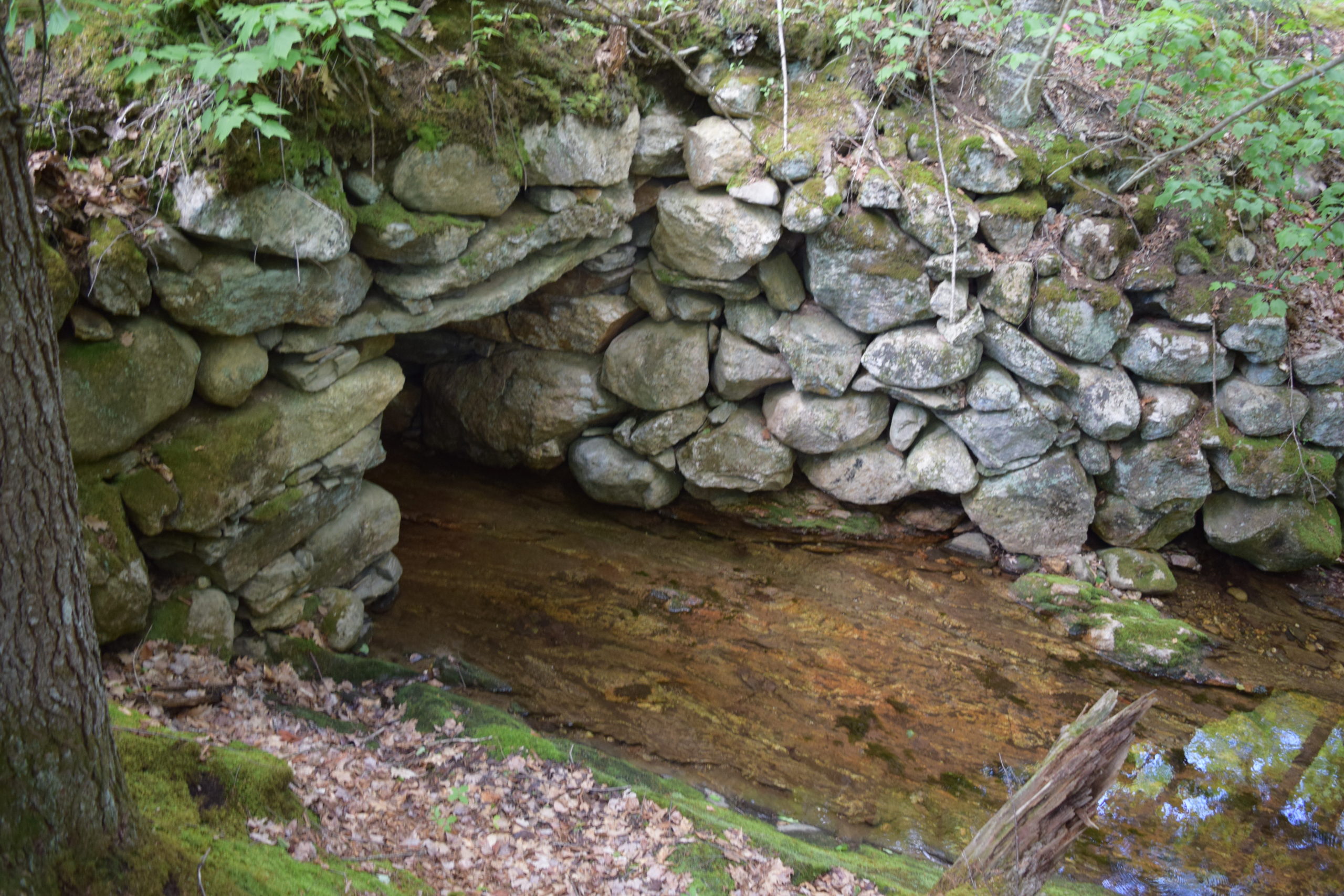
Churchill Bridge
[Mountain Road across Bicknell Brook, one mile west of junction with Sodom Road] Built about 1797, the Churchill Bridge is a dry laid, rubble stone structure located in a now unpopulated section of Buckfield. It was apparently built by William Churchill – whose homestead was nearby the bridge site – in lieu of that year’s abatement of his highway tax.
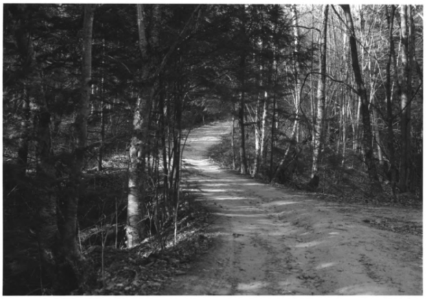
The type of monolithic stone construction used in the Bridge appears to have been common practice in Maine communities during the 18th and first half of the 19th centuries. The tradition of this construction technique persisted well into the 1890s. At the time Buckfield had twenty bridges built entirely of stone, one of which had two spans, and an additional sixteen using a combination of materials (there were only six truss bridges and one concrete culvert). All of the latter had been rebuilt before 1900 raising the question of whether they too may originally have been built of stone only. It is not surprising that early bridges in Maine were built of stone, given the abundance of materials to be found.
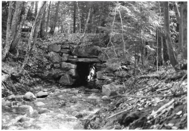
According to local historians, the area in which the Churchill Bridge is located was among the first settled in Buckfield (incorporated 1793). The neighborhood of homesteads along Mountain Road was known as “Owls Head” in reference to the nearby hilltop of the same name. It was a dispersed community with upwards of twenty residences during the peak of settlement well before the mid-nineteenth century. Thereafter, and increasingly after the Civil War, the area was abandoned to the point that only two buildings were standing in 1994.
The Bridge joins the now ill-fated c. 1808 Thompson’s Bridge in Industry as an example of early dry laid stone bridge construction. A similar stone bridge is over Grant Brook in a wooded section of Brighton. A third stone structure is the equally early Grist Mill Bridge in Lebanon, which is distinguished by its double span with center pier and wooden deck.
Churchill Bridge 2022
The deck on the bridge is still intact, as are the boulders beneath the deck. Access to the bridge is over a climb narrow, very rough road, not meant for ordinary automobiles. Beyond the bridge is a waterfall that feeds the Bicknell Brook. During late Spring the flow over the massive outcrop allows only a narrow stream.
Stream
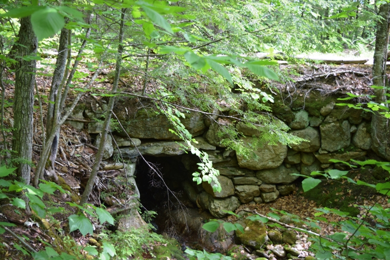
Under the Bridge
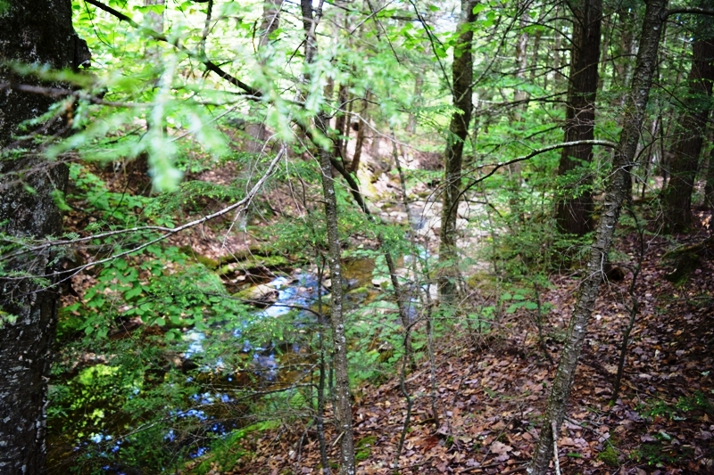
Upstream near Bridge

Waterfall Upstream??????????????????????????????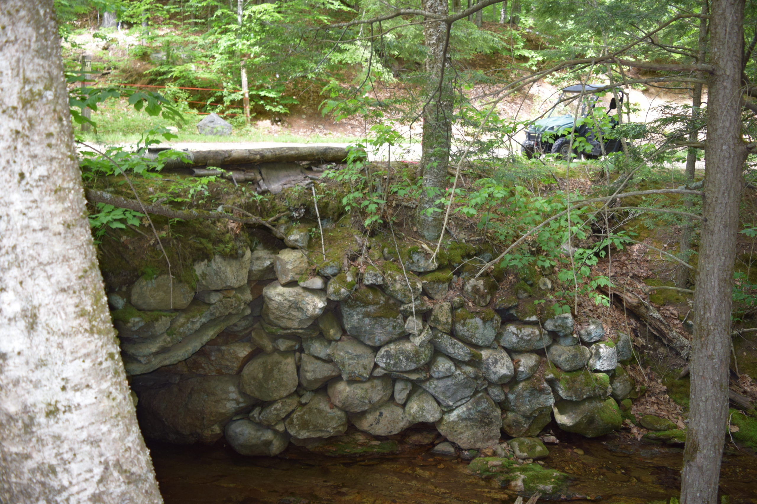
At the Bridge
Hall, Enoch, House
[Bean Road west side, 0.5 miles southeast of junction with Maine Route 117] The Enoch Hall House in rural Buckfield is a 1 ½ half story Federal period cape, apparently built in the early 1790s. In addition to its architectural features, primary significance is in the extensive 19th century landscape murals that decorate the upper rooms. Enoch Hall (1763-1835) settled the property in 1783, having moved from Windham. Nine years later he apparently moved from the original log house on the property to the existing house.
")
Enoch Hall House in Buckfield (1993)
The Enoch Hall House in rural Buckfield is a 1 ½ half story Federal period cape, apparently built in the early 1790s. In addition to its architectural features, primary significance is in the extensive 19th century landscape murals that decorate the upper rooms. Enoch Hall (1763-1835) settled the property in 1783, having moved from Windham. Nine years later he apparently moved from the original log house on the property to the existing house.
Enoch Hall House (2020)
While there, Hall distinguished himself in politics by representing the Town of Buckfield at the Massachusetts General court; as a member of the 1819 convention that framed the Maine Constitution; and as the Town’s representative to the Legislature in 1820-21. Sometime after Hall’s death and prior to 1858 the property was acquired by William F. Robinson, a farmer who served as a First Lieutenant in the Buckfield militia company during the Civil War.
The house changed hands twice during the early twentieth century and in 1930 it was acquired by Ernest Bean, Sr., the grandfather of owners in 1993, the year of its nomination to the Historic Register.
The 1790s building’s similarity of the two mantelpieces on the first story to a 1806 pattern book design indicates that the interior finish may not have been completed at the earlier date. Apart from its architectural features, the Hall house is notable for the extensive decorative painting on the second floor. These images, which appear in the narrow hall as well as on the walls and ceilings of the two large bedrooms, belong to the so-called “Porter School” of landscape mural painting. Probably executed during the mid to late 1820s or early 1830s, this form of interior decoration was quite popular in rural Maine.
Long, Zadoc, Free Library
")
Zadoc Long Free Public Library (2013)
[Maine Route 117 south side, at junction with Maine Route 140] Erected in 1901 by then U.S. Secretary of the Navy John D. Long in memory of his father, the Zadoc Long Free Library is a modest but striking building. It was designed by Maine’s foremost architect of the period, John Calvin Stevens. The creation of the Library was apparently the first effort made in Buckfield (population in 1900, 1,139 persons) to establish such an institution.
The Library is a one-story hip roofed frame building with wood shingles that rests on a fieldstone foundation on a terraced site in Buckfield’s village center. Its broad central entrance is sheltered by a gabled overhang.
In 1921 the trustees of the library took the unusual step of opening the stacks to the public. Prior to that time only the librarian and librarian’s assistant were permitted in the stacks, the typical arrangement in the period.**
Record, Ezekiel C. and Mariam I., Homestead
[8 Bean Road, view from the house]
 The E. C. and M. (Ezekiel Courtney and Mariam Irish Record) Homestead is a late transitional Federal to Greek Revival style Cape Cod house with an attached kitchen ell, shed, and barn on 22 acres.
The story-and-a-half side-gable house is located at the intersection of Bean and East Buckfield roads in the Oxford County town of Buckfield. An associated field is located directly across Buckfield Road and a wood wood lot extends along East Buckfield Road. The Record house has a small garden shed of recent (c. 2010) construction and although non-contributing to the historic status, it is generally compatible with the property. The clapboard structure, built in 1843-44, faces southwest in a rural setting with few nearby buildings.
Union Church
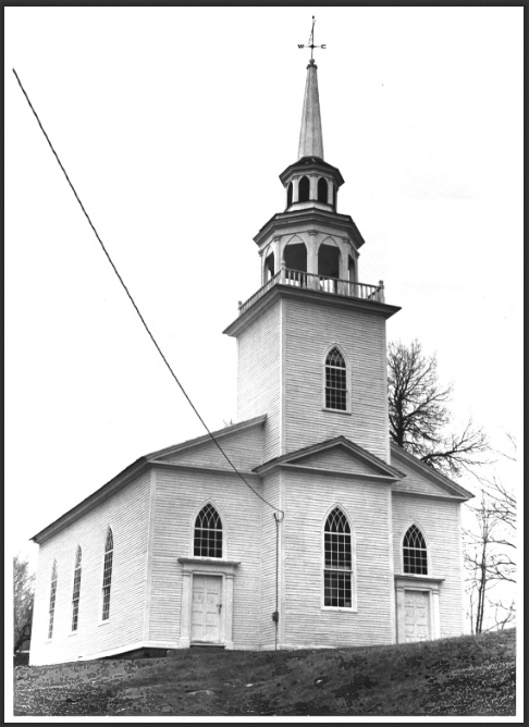
Buckfield Union Church (1979)
[off Maine Route 140] The Union Church in Buckfield, built in 1832, is an outstandingly handsome and well-proportioned example of a late Federal meeting house with transitional Gothic features. The 91-foot spire is regarded as a model of proportion and grace. Originally it was called Union Chapel, in the building of which nearly all the prominent citizens of the community of various religious denominations zealously participated. It was modeled in part after the Universalist Church in Livermore with the steeple design based on that of the Universalist Church in Norway – a happy accident which produced a building far better than either. [Buckfield Union Church 2020]
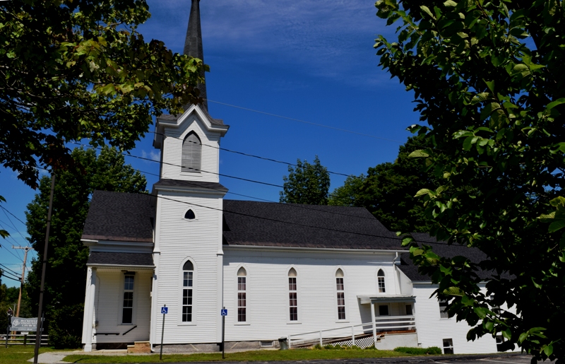
By the end of the 19th century, the church had fallen into disuse and was in danger of serious deterioration. Fortunately, John D. Long, a Buckfield native who served as Secretary of the Navy under McKinley and Theodore Roosevelt, offered a generous contribution for repairs provided the town would purchase it for use as a town hall. The townspeople agreed and bought the church for $75.00. Shortly afterward, Long procured a bell, cast in the mid-1800s from a Spanish mission on the Texas gulf coast.The church again fell into disrepair in the 1960’s but thanks to a group of dedicated citizens, restoration was begun in 1971. Beautifully sited on a hill overlooking the town, this handsome structure well deserves its reputation as a local landmark.** [Frank A. Beard photo]
The Union Church is one of a relatively small number of surviving Federal style religious buildings in Maine characterized by a central pavilion which projects from the main block, and a tower that either rises through or straddles both sections.
2020
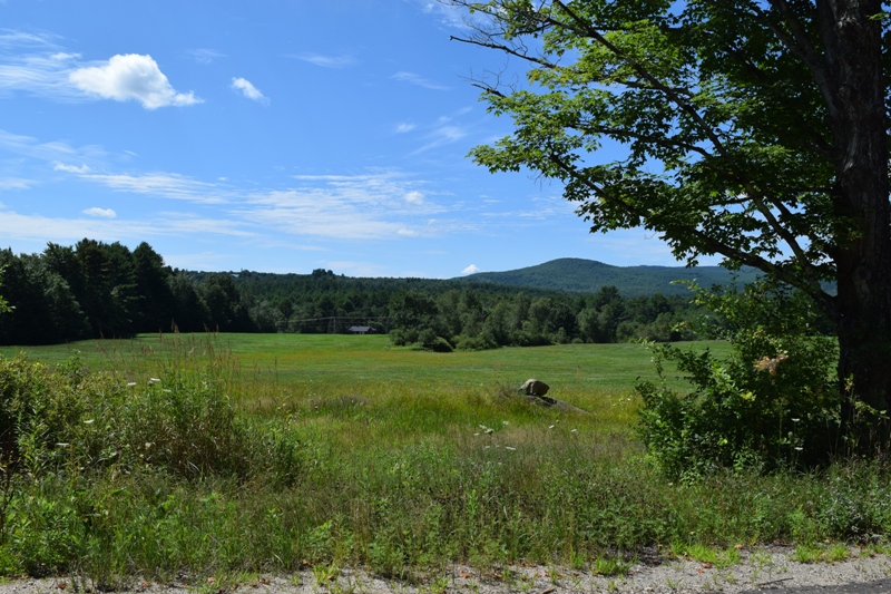
Rural Buckfield on North Hills Road is a study in farms with barns, crops, and fields. It also offers panoramic views of Maine’s western mountain ranges.
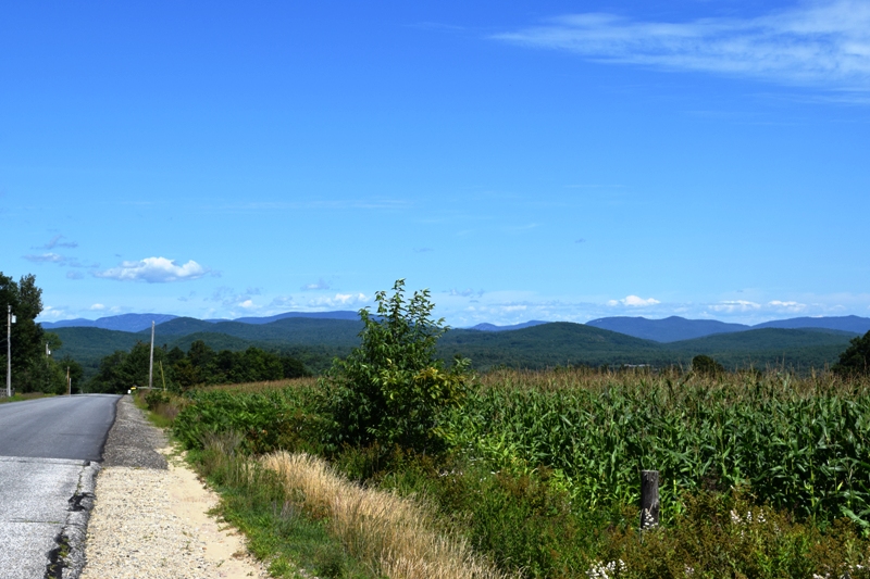
Cornfield on North Hill Road with view of the Western Mountains (2020)
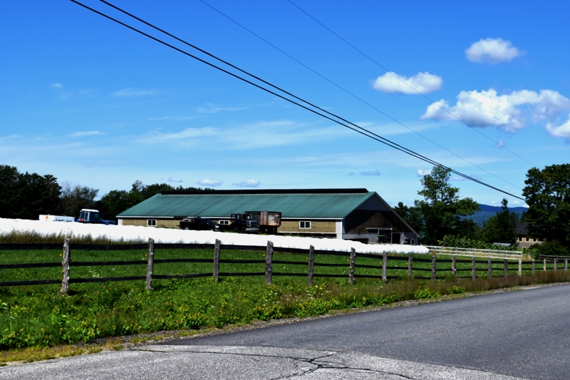
Farm on North Hill Road with harvested hay wrapped for storage. (2020)