 N43° 52' 29.96\" W69° 29' 24.33\"")
Going to Monhegan from New Harbor (2013) @

Location Map for Bristol
| Year | Population |
|---|---|
| 1970 | 1,721 |
| 1980 | 2,095 |
| 1990 | 2,326 |
| 2000 | 2,644 |
| 2010 | 2,755 |

Population Trend 1790-2010
| Geographic Data | |
|---|---|
| N. Latitude | 43:55:18 |
| W. Longitude | 69:29:36 |
| Maine House | District 90 |
| Maine Senate | District 13 |
| Congress | District 1 |
| Area sq. mi. | (total) 62.5 |
| Area sq. mi. | (land) 35.5 |
| Population/sq.mi. | (land) 77.6 |
County: Lincoln
Total=land+water; Land=land only |
|
Clipper Ship Built Here
- Sparkling Sea–1854
[BRIS-tul] is a town in Lincoln County, incorporated on June 21, 1765 from a tract known as Walpole, Harrington and Pemaquid. It was named for England’s maritime city of Bristol.
From 1815 to 1847 it ceded land to Nobleboro, Bremen and Damariscotta. Finally, in 1915 it provided land to form the town of South Bristol, thus the drop in the 1920 census count. It has maintained its boundary intact since that time.
Bristol was settled by Europeans as early as 1625. The Pemaquid Patent granted in 1631 included the area. On the east bank of the Damariscotta River, Sir. William Phipps built Fort William Henry in 1692, but it was overrun by the French in 1696.
Col. David Dunbar, who became superintendent and governor of the Province of Sagadahoc in 1729, repaired the fort in 1729-1730 calling it Fort Frederick and naming the place Harrington. The historic Harrington Meeting House was built between 1772 and 1775 (see below).
")
Working on Traps at New Harbor (c. 1950) George French
The southern end of the town consists of Pemaquid Neck on which the village of New Harbor is located, along with Pemaquid Beach and Pemaquid Light, one of many lighthouses along Maine’s coast. It was visited by Europeans as early as 1569.
The Pemaquid area is said to be the home of the Indian Samoset, who greeted the Pilgrims in 1621 in English. New Harbor is a popular departure point for Monhegan Island. Fishing boats at “The Gut” in South Bristol
 N43° 50' 12.63\" W69° 30' 22.60\"")
Pemaquid Light (2013) @
 N43° 50' 12.74\" W69° 30' 21.97\"")
Shore near the Light (2013) @
Bristol hosts three nature preserves managed by the Nature Conservancy. Bass Rock at Round Pond is a preserve whose twelve acres look out on Muscongus Sound. La Verna Preserve features hardwoods and conifers surrounding 3,600 feet of shore frontage on Muscongus Bay on the Pemaquid Peninsula. The dense forest gives way to swamp, freshwater marsh and overgrown farmland in places.
 N43° 50' 12.58\" W69° 30' 24.33\"")
Lighthouse Museum (’13) @
 N43° 50' 12.94\" W69° 30' 21.62\"")
From the Tower (2013) @
 N43° 50' 12.75\" W69° 30' 21.28\"")
The East Shore (2013) @
Rachel Carson Salt Pond Preserve, in New Harbor, is a popular salt pond and tidal pool area along Route 32 where Rachel Carson came to observe the diverse marine life. Across the road are fields and forest with rough trails to an old ice pond and high views over Muscongus Bay.
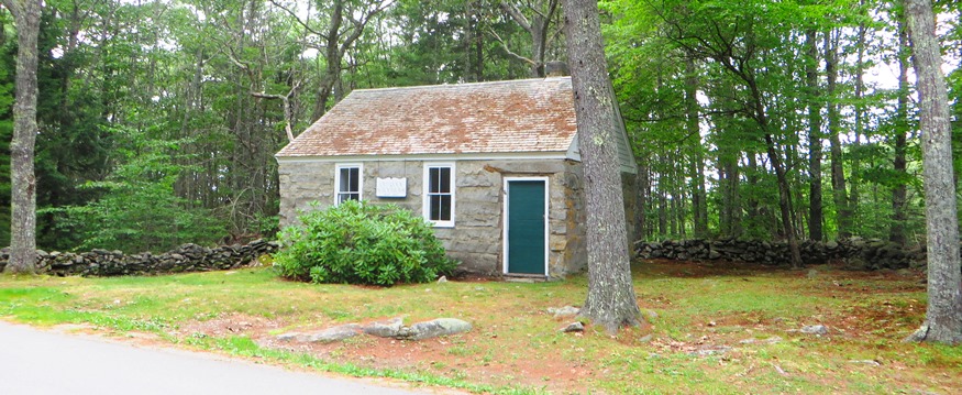
1835 Rock School House with Stone Wall on Rock School House Road (2015)
 N43° 52' 31.67\" W69° 29' 28.50\"")
New Harbor Services (2013) @
 N43° 52' 24.85\" W69° 30' 5.03\"")
New Harbor Gallery (2013) @
 N43° 52' 21.44\" W69° 30' 10.62\"")
Community Hall (2013) @
Form of Government: Town Meeting-Select Board-Administrator.
More Videos!
Additional resources
Blaney, Aaron. Memo Book, 1824-1834. (Cataloger Note: A diary from 1824-1834 kept by an unidentified person, probably Aaron Blaney of Bristol, Maine. Entries are headed Bristol and outline daily activities, service in the Maine legislature and as a justice of the peace in Bristol, deaths of parents and children, etc. . . . Aaron Blaney came to Bristol, Maine, from Roxbury, Massachusetts. He had a large mercantile business, served as treasurer, justice of the peace and postmaster of Bristol, and was elected to the Maine legislature in 1824-1827. He died on July 31, 1834. [University of Maine, Raymond H. Fogler Library, Special Collections]
Bristol, Maine Bicentennial, 1765-1965. 1965. Damariscotta. News Print Shop.
Burrage, Henry S. Military Operations at Pemaquid, in the Second War with Great Britain … Read before the … society, May 20, 1886. Proceedings of the Maine Historical Society. Portland, Me. The Society. 1892.
Chadbourne, Ava Harriet.Maine Place Names and The Peopling of its Towns.
Hoyt, Elizabeth E. Man And Nature In Bristol: a Contribution To The Bi-Centenary Of The Town From The La Verna Foundation. [Bristol, Me.? La Verna Foundation. 1965. (Damariscotta, Me. Printed by The News Print Shop)
Isaacson, Dorris. Maine: A Guide Downeast.
Johnston, John. A History of The Towns of Bristol and Bremen in the State Of Maine, Including the Pemaquid Settlement. Albany, N.Y. J. Munsell. 1873.
*Maine. Historic Preservation Commission. Augusta, Me.
Weston Family. Account Books, 1770-1840. (Cataloger Note: Arunah Weston moved to a farm in Bristol (later Bremen), before the Revolutionary War. In addition to farming, he was sometimes employed in ship building. Account books of Arunah, Daniel and Eliphaz Weston of Bristol (later Bremen) record items sold to various individuals and payment received. Goods sold include rum, sugar, tea, hay, turnips, etc. Many of the payments were made by barter, including with days of labor or with materials such as timber, hay or beef.)
Slide images by Rebecca A. Williams (2007)
National Register of Historic Places – Listings
Arch Bridge, over the Pemaquid River on Benner Road
Cottage on Kings Row
The Cottage on King’s Row is a notable example of a Gothic Revival cottage that reflects the influence of mid-19th-century architects and authors Alexander Jackson Davis and Andrew Jackson Downing. Built about 1854, this wood frame building has the distinctive characteristics of the Gothic Revival style including asymmetry, steep roof slopes decorated with vergeboard and finials. The house appears to have been built by a ship’s joiner, whose skilled hand is evident in the intricately carved porch supports and exterior moldings.
The Cottage is on a stretch of the main road (Route 32) in Round Pond, a village of the town of Bristol. Said to have been a community of sea captains, three of the neighboring houses were designed at about the same time and in the Gothic Revival style. Only this Cottage retains its historic design and structure.
Fort William Henry
Northwest of Pemaquid Beach Pemaquid Beach [See Fort William Henry.]
Harrington Meetinghouse
")
Harrington Meeting House (2001)
[Northwest of Pemaquid on Old Harrington Road Pemaquid] After years of argument, residents decided to build three meetinghouses. In 1772 people who wanted only one meeting house put up a building frame in the center of town, Bristol Mills. A town meeting ordered the frame moved to land, donated by William Sproul in 1768, in Harrington village. The meeting house was erected and accepted by the Town in 1775, the same year that Walpole [now in South Bristol] and Broad Cove meetinghouses were accepted.
In the late 1840s, the building was moved across the old cemetery to face the Old Harrington Road. Everyone on the two peninsulas, Christmas Cove to Pemaquid Point, had to worship at Harrington. It was mandatory that everyone attend service to have any standing in the town. The only Town Meeting in any of the meetinghouses was held at Harrington in 1778. The Rev. Alexander McLain, born in Scotland, was hired preach at all three meetinghouses in the town, 1773-1798.
Required renovation in the 1960s revealed the original framework of the building. The town decided to restore the building as it was in the 1770s. This was an actual restoration except for the balcony which has been installed with a flat floor and no pews in order to have a museum of and for the town. Books, maps, pictures, clothing and other memorabilia have been collected, all relating to Bristol.*
Loudville Church, Center of Louds Island Loudville
Pemaquid Point Light
[Pemaquid Point] Spectacularly located on a high promontory with long dramatically sea grooved ledges running southwesterly for a third of a mile into the ocean, it was built in 1827 and rebuilt in 1857. It has been the scene of a number of tragic shipwrecks because of that long ledge. The station has three structures: a stone light tower, an attached keeper’s quarters and a red brick bell tower. The 34 foot, square tower stands 79 feet above sea level with an 11,000 candlepower automated light. The keeper’s quarters, also of stone, is a one-story building. The brick bell tower is 12 feet high. [See photos above.]
Pemaquid Point Light is an extremely important navigational mark between the entrance to Johns Bay and Muscongus Bay. In 1934 the keeper’s house and surrounding land was given to the State and is now a state park with a lighthouse and maritime museum. On September 5, 1813, during the War of 1812, people gathered on this site to witness the epic ship battle between the British brig Boxer and the United States brig Enterprise, only a short distance from shore. The Boxer was defeated.*
Pemaquid Restoration and Museum, North of Pemaquid Beach at Pemaquid Point Pemaquid Beach
Union Church
")
Union Church (2001)
[east side of Maine Route 32, .05 miles south of junction with Back Shore Road, Round Pond] The 1853 Union Church, also known as the Brown Church, is a modest Gothic Revival style wooden frame building that features board-and-batten siding and pointed arch windows. It is one of only a handful of such church buildings that survive in Maine. The church building was probably dedicated late in 1853 or in 1854. For a brief time the church building was used by the Baptists and Adventists, but it appears to have fallen into disrepair during and immediately after the Civil War. Renewed interest during the 1870s resulted in repairs under the leadership of the Union Sewing Society. Local residents were served by a variety of pastors during the summer months.
Church records indicate that on March 1, 1853, a committee of seven local men was formed to build the meeting house. Records make no reference to the involvement of an architect or master builder. Although the general scale of the Union Church is not unlike others in Maine, its board-and-batten siding, the configuration of its pointed arch windows and doorway, and the preservation of its original exterior and interior color schemes are notable characteristics.*