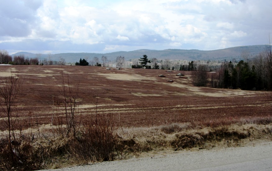
Blueberry Barrens in Aurora on Route 179 April 2013)

Location Map for Aurora
| Year | Population |
|---|---|
| 1970 | 72 |
| 1980 | 110 |
| 1990 | 82 |
| 2000 | 121 |
| 2010 | 114 |
| Geographic Data | |
|---|---|
| N. Latitude | 44:52:10 |
| W. Longitude | 68:15:45 |
| Maine House | District 137 |
| Maine Senate | District 7 |
| Congress | District 2 |
| Area sq. mi. | (total) 38.9 |
| Area sq. mi. | (land) 37.3 |
| Population/sq.mi. | (land) 3.1 |
County: Hancock
Total=land+water; Land=land only |
|
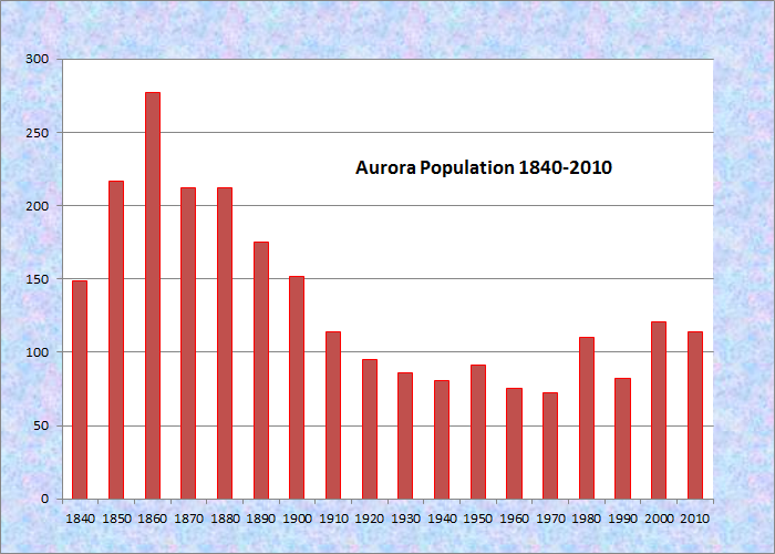
Population Trend 1840-2010

Town Line Sign Entering Aurora
[ah-ROAR-ah] is a town in Hancock County, incorporated on February 1, 1831 under the name of Hampton, formerly Plantation Number Twenty-seven, also known as Richards. On February 6, 1833 its name was changed to Aurora, the Roman goddess of the dawn, appropriate for a downeast town where the dawn come early to America.
 N44° 51' 21.48\" W68° 19' 40.56\"")
Aurora Town Office and Post Office (2013) @
 N44° 51' 22.68\" W68° 19' 40.26\"")
Fire House adjacent to Town Office (2013) @
The town is located north of Ellsworth on Route 179 at its junction with the major east-west Route 9 – “The Airline.” The village is on the Old Airline Road, a short loop north of The Airline.
 N44° 51' 13.02\" W68° 19' 44.34\"")
Farmhouse & Barn (2013) @
 N44° 51' 8.64\" W68° 19' 45.42\"")
Farmhouse & Barn (2013) @
An excerpt from Maine: A Guide Downeast:
Hunters and fishermen now use the Village Inn, former stagecoach stop [on the Airline]. Increasing the popularity of the Airline Stage in the Nineteenth century were tales of robbers bold. Wesley and Hardwood Hills [in Aurora] are said to have been the scene of many attacks by highwaymen because the hills were so steep the horses could not outrun the robbers. . . . Most of the lumber sawed in Ellsworth was cut north of the Airline but lumbering declined and the railroads never reached Aurora.
– – – –
The Great Pond road leads north from Aurora to the town of the same name. Blueberry barrens mark the landscape on the way. The Silsby Plain Road leads through the barrens to a natural feature created by glaciers that moved through the area. [See also the Agassiz Outcrop in nearby Ellsworth.]They formed a delta where the melt water was “deposited into a narrow marine inlet when the sea was at its maximum inland extent.”1
The Silsby Plain is a sandy remnant of that process and a favorable site for blueberry cultivation. Another glacial feature, The Whalesback, is located farther east on Route 9.

Large House and Red Barn with sign: Union River Telephone @
 N44° 51' 50.28\" W68° 18' 25.98\"")
Airline Community School on the Great Pond Road
(2013) @
 N44° 50' 49.56\" W68° 19' 43.26\"")
1827 Brick Schoolhouse on Route 179 (2013) @
")
Interior of Brick Schoolhouse (2013)
 N44° 50' 49.68\" W68° 19' 43.74\"")
Blueberry Barrens in Aurora on Route 9 (2013) @
")
Giles Pond on the Giles Pond Road off Route 179 (2013)
 N44° 50' 0.66\" W68° 19' 6.66\"")
Common Mergansers in Giles Pond (2013) @
")
Turkey on a Blueberry Barren West of the Great Pond Road (2013)
")
Silsby Plain Road through a Blueberry Barren west of the Great Pond Road (2013)
Form of Government: Town Meeting-Select Board.
Additional resources
1 Neil, Craig D., et al. [Maine Geological Survey and U.S. Geological Survey] “Hydrology and Water Quality of Significant Sand and Gravel Aquifers in parts of Hancock, Penobscot, and Piscataquis Counties, Maine.” Augusta, Me. Maine. Department of Conservation. 1998.
Isaacson, Dorris. Maine:A Guide Downeast, p. 393-394.
Silsby, Herbert T. A History of Aurora, Maine. Ellsworth, Me. Hancock County Publ. 1958.
National Register of Historic Places – Listings
Brick School House
[School House Hill] First settled in 1808, Aurora had only nine heads of families yet by that year they had already erected a school. In 1825 it was attended by 35 children. The plantation built a new brick school house in 1827: 25 feet square, with seats on three sides.
The Brick School House is the oldest public brick building in Hancock County and may have been the first. When erected it was so far advanced for school house construction that none in Eastern Maine came close to comparing with it. Twenty years later, the State set minimum standards for school construction considerably below those already achieved in Aurora. Samuel Silsby, the first settler and acknowledged leader, possibly influenced the choice of brick construction since he attended a brick school in Connecticut.
Aurora, always a small town, used it as a school until 1918. It later served as a town hall. The building deserves recognition as a remarkably preserved example of a late Federal school house in an extremely remote area, reflecting the determination of early settlers to provide a quality educational opportunity. [See photos above.]