
Location Map for Andover
| Year | Population |
|---|---|
| 1970 | 773 |
| 1980 | 850 |
| 1990 | 953 |
| 2000 | 864 |
| 2010 | 821 |
| Geographic Data | |
|---|---|
| N. Latitude | 44:37:16 |
| W. Longitude | 70:45:13 |
| Maine House | District 117 |
| Maine Senate | District 18 |
| Congress | District 2 |
| Area sq. mi. | (total) 57.5 |
| Area sq. mi. | (land) 57.4 |
| Population/sq.mi. | (land) 14.3 |
| County: Oxford
Total=land+water; Land=land only |
|

Population Trend 1820-2010
")
The Baseball Field (2010)
")
Veterans Memorials in the Park (2010)
[AN-dowe-ver] in Oxford County, was incorporated on June 23, 1804 as East Andover from East Andover Plantation, but adopted its current abbreviated name on June 13, 1820.
")
Bandstand in the Park (2010)
")
Civil War Memorial (2010)
The main village features a “town square” park, adorned with a bandstand and several veterans memorials.
Native American Molly Ockett was born about 1740 into the Pigwacket tribe near Fryeburg and was buried in an unmarked grave in Andover’s Woodlawn Cemetery in 1816.
")
General Store & Diner (’10)
")
Historical Society (2010)
Ezekiel Merrill of Newbury, Massachusetts and his family settled here in 1789 in a log cabin he had built the previous year. In 1791, Merrill had built a much larger house which, with additions, now stands at the Merrill-Poor House, co-named for Sylvanus Poor who married Merrill’s daughter. Their sons and grandson were successful in railroad and finance industries.
")
Cows, Pasture and Rolling Hills (c. 1950)
")
First Congregational (2010)
Throughout the 19th century subsistence farming, small-scale lumbering and home-based industries characterized the local economy. After the Civil War the area became a popular destination for sportsmen and vacationers attracted to the nearby Richardson Lakes (see Township C).
")
Andover Fire Dept. (2010)
 on South Main Street in Andover")
Lone Mountain Grange and the Andover Town Hall (2010)
Andover’s population declined by about 90 people between 1990 and 2000, not much more than the 790 of 1890. In that year, planning began for a fire station to protect the two hotels, two boarding houses and other structures in the village.
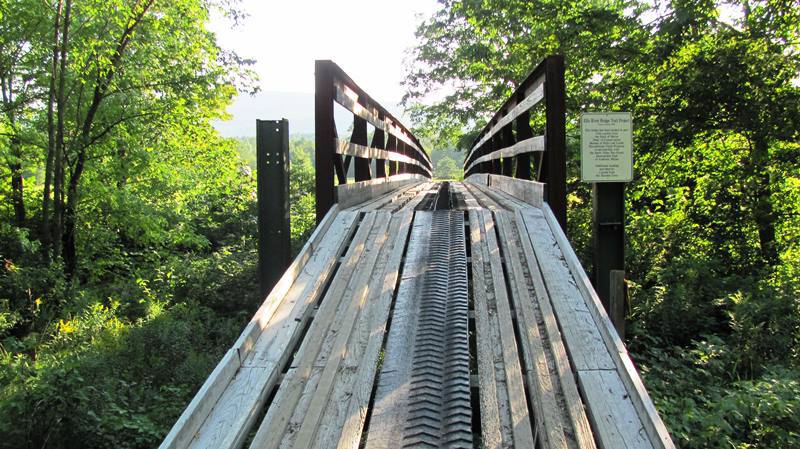
The Ellis River expands in Andover with the confluence of its West Branch, Abbot Brook, Bog Brook, and Moody Brook. A canoe trip launch area is located near the bridges on Route 120.
")
Truss Bridge over the Ellis River (2013)
")
Pedestrian/Small Vehicle Bridge at the Ellis (’13)
The fourth of five meteorites to land in Maine dropped on Andover August 5, 1898. Given that history, it is appropriate that Andover is the site of the Telstar communications satellite ground station. The region’s high school bears the satellites name. Telstar 1 was launched on July 10, 1962.
")
Telstar Station (c.1962)
")
Plaque Commemorating the Telstar Station (2010)
AT&T built the ground station in Andover similar to, but larger than, the ground station used for Echo, an earlier communications satellite. A French station used a duplicate of the AT&T horn antenna while the British station used a parabolic dish. The satellite was in position for transatlantic relay for a maximum of 102 minutes per day. Telstar relayed the first live trans-Atlantic television transmission as well as picture facsimile, telephone, and data relay.
AT&T’s Telstar was not only a tremendous technical success, but the international reaction was spectacular. A U.S. Information Agency poll showed that Telstar was better known in Great Britain than Sputnik had been in 1957.
On August 31, 1962, President Kennedy signed the Communications Satellite Act which gave a monopoly on international communications via satellite to a new corporation called Comsat.
The Appalachian Trail crosses the B Hill Road in nearby Andover North Surplus Township. Hikers often hitch a ride to Andover to pick up mail and resupply at the General Store.
Source: photo “Cows, Pasture and Rolling Hills (c. 1950)” courtesy of Maine State Archives, George French Collection.
South Andover
South Andover is a village within the town of Andover. It is home to the historic Lovejoy covered bridge which spans the Ellis River.
The photo below was taken by the Maine Department of Transportation. This bridge, built in 1868, is 70 feet long and spans the Ellis River. It has Paddleford trusses and is Maine’s shortest covered bridge. The name comes from the Lovejoy house, which was on the Eastern side of the river. In 1936, waters were high and two boys decided to canoe near the bridge. Water was a few inches below the bottom of the bridge so they decided to try and paddle up next to the bridge. Their hope was to let the bridge hold the canoe. But the water pressure passing underneath was so strong that the canoe got sucked under water and the boys were tossed. Luckily a local guide was canoeing in the area and was able to rescue them. In 1983 a heavy sand truck fell through the deck of the bridge while trying to cross the span. The bridge was reinforced in 1984 to carry local traffic.
Form of Government: Town Meeting-Select Board.
Additional resources
“Amazing Maine Get-Away – Maine’s Western Mountains.” [Merrill-Poor House] http://www.vacationhomerentals.com/vacation-rentals/Andover-Maine-vacation-rental-home-proID-34720.html (accessed January 2, 2015)
Andover: the First 175 Years. Prepared by the Friday Club. Andover, Maine. 1979.
Glimpses of Olde Andover. Created by the Andover Service Circle. Andover, Me. The Circle. 1978.
History of Andover, Maine: purchase of the township and distribution of the land. Rumford, Me. Rumford Falls Times. 1904.
*Maine. Historic Preservation Commission. Augusta, Me. Text and photos from National Register of Historic Places.
National Aeronautical and Space Administration, at http://roland.lerc.nasa.gov/~dglover/sat/telstar.html
Poor, Agnes Blake. The Andover Memorials. Bryant Pond, Me. Inman Printing. 1997.
Richards, S. Wallace. Diary, 1892. (Diary of a Maine farmer. Entries include brief comments on the weather and record the daily life of S. W. Richards on his farm and in the community.) Special Collections, Fogler Library, University of Maine. Orono.
Spidell, Robert A. The Pynelis journals: transcribed from the original journals by Robert A. Spidell. San Clemente, CA: Robert A. Spidell. c2003.
Warren, Elizabeth. Notebook, 1923-1930. (A notebook of a teenager in the 1920’s living in Andover, Maine.) Special Collections, Fogler Library, University of Maine. Orono.
National Register of Historic Places – Listings
Andover Hook and Ladder Co. Building
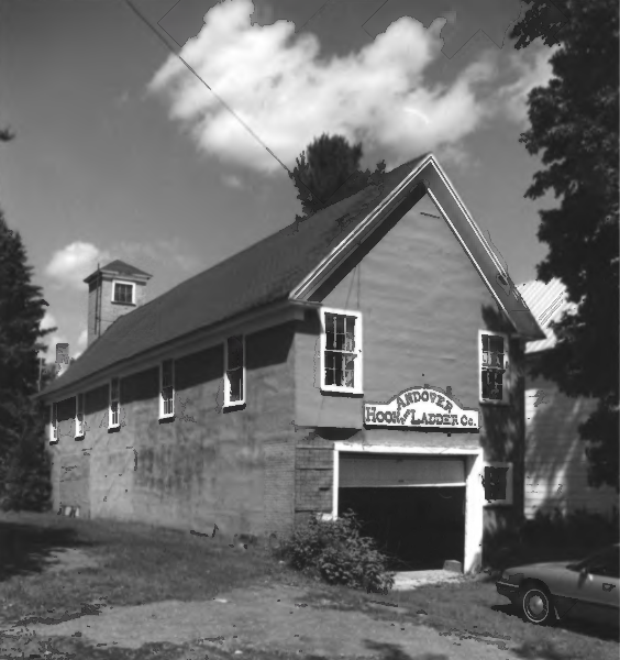
Hook & Ladder Co. (2000)
[39 Elm Street] The 1904, Andover Hook and Ladder Company Building is a long, narrow two-story frame building that housed Andover’s firefighting apparatus and served as a meeting place for firemen and other community groups. Formed in 1890, its equipment was stored in an existing building. By 1904 that building was moved to its present location and an additional section amounting to two-thirds of the existing building was added. The fire station was in use until 1987 when a new building was built near the commercial district. Town has deeded the original property to the Andover Hook and Ladder Association which has assumed responsibility for its preservation. [Kirk F. Mohney photo]
When it was built, the fire station stood near the Andover Common, village school (no longer in existence), Congregational Church and town hall. It is part of an important cluster of historic properties in the center of the village.
The building is one of the few historic fire stations left in smaller communities. Among them are the 1876 Massasoit Engine Company Firehouse in Damariscotta and the 1892 Old Fire Engine House in Orono. Historic urban fire stations include the 1837 Spring Street Fire House in Portland at 155-157 Spring Street, the 1879 Engine House in Auburn, the 1897 Hose House Number 5 and the 1902 Fire Engine House Number 6 in Bangor.*
Andover Public Library
[Church Street] The Andover Public Library building is a very late example of octagon design and was originally one of only two churches in Maine built in this form.
In 1795 settlers formed the Social Library society, allotted 12 shillings for the purchase of books and acquired 75 volumes. This informal arrangement continued until 1891 when money was donated for a free library and the Andover Public Library Association was formed.
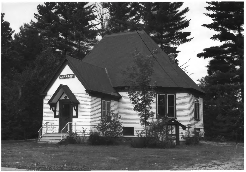
Andover Public Library (1975)
Built in 1899 as a Universalist Church, it is joined only by the 1881 Temple at Ocean Park in Old Orchard Beach as an example of octagonal ecclesiastical architecture in Maine. It is the last 19th century Maine building in this design, which can be traced to the tradition begun by Orson Squire Fowler, who, though not an architect, popularized this this space saving and light increasing design through his 1848 book, The Octagon House. [Historic Preservation Commission photo]
In 1943, the Universalist Conference in Portland donated the former Church building to the Library Association, which had occupied a room in the town hall.*
Lovejoy Bridge
")
Lovejoy Covered Bridge (1970)
[over Ellis River, South Andover] This bridge was built in 1868, to serve as a connector between the West River Road from Rumford Point to Andover, and the East River Road from Rumford Center.
This wooden structure is about 70 feet long, 20 wide and 22 high. Overhead clearance is 14 feet. It is built on granite block abutments set 65 feet apart at a narrow point in the river. It is Maine’s shortest covered bridge. The basic engineering concept is best described as being of Paddleford Truss construction or a modification of a Long Truss System. The bridge was reinforced in 1984 to carry local traffic.* [Maine Parks and Recreation Commission photo]
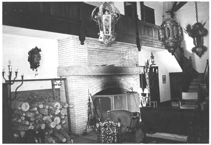
Merrill-Poor House
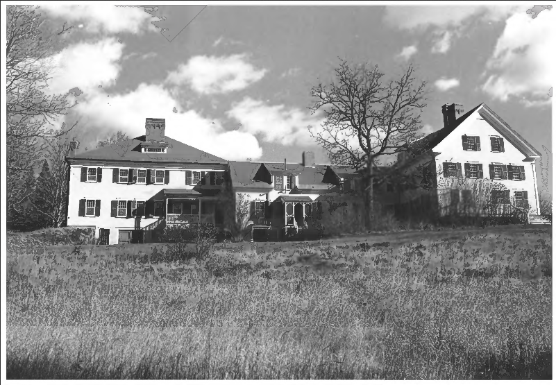
Merrill-Poor House (1975)
[northeast of Andover on Maine Route 120] This House is an example of a homestead that evolved architecturally over many years, with alterations reflecting the changing lifestyles of its owners. Begun in the-1790’s as an ambitious farmhouse, it did not reach its present state as a summer retreat until the 1890’s.
The main house is a massive 2 ½ story gable roof dwelling on a granite foundation with a large central chimney. Beyond its architectural importance and that it is oldest and largest frame house in Andover, the House stands as the one permanent anchor which held fast during the history of a remarkable family.
Merrill-Poor House (1975)
The family epitomizes the evolution of the devout puritan frontier ethic of the nineteenth century into twentieth century economic comfort and stability. Ezekiel Merrill was the first of a group of Revolutionary War veterans to occupy the land they had purchased while in the army. In 1788 he built a log house to which he brought his wife, seven children, and possessions in seven birch bark canoes up the Androscoggin and Ellis Rivers. He then began work on what is now the main body of the Merrill-Poor House, an enormous task not completed until 1791. [Frank A. Beard photos]
His daughter, Mary married Sylvanus Poor, son of Eben Poor, one of the earliest settlers. The house was left to Mary and Sylvanus upon Ezekiel’s death. In 1890 the house underwent a major renovation and in 1896 a large structure called the “New House” or the “Great Hall” was added.*
A 2014 promotion for the house reads “Historic country lodge in Maine’s beautiful western mountains with private swimming pond and beach on property, close to lakes, streams and mountains. Nearby world-class fishing . . .), golfing (Bethel Inn & Sunday River), and ski areas (Sunday River, Saddleback, Mt. Abram, Black Mountain). Sleeps 25+ in warm weather, 16+ in cold weather. Summer and winter rentals available.”