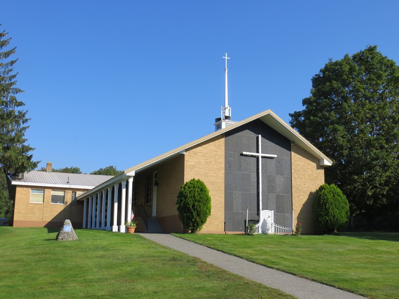
Church on Shaker Hill in Alfred (2012)

Location Map for Alfred
| Year | Population |
|---|---|
| 1970 | 1,211 |
| 1980 | 1,890 |
| 1990 | 2,238 |
| 2000 | 2,497 |
| 2010 | 3,019 |
| Geographic Data | |
|---|---|
| N. Latitude | 43:28:55 |
| W. Longitude | 70:44:18 |
| Maine House | District 21 |
| Maine Senate | District 32 |
| Congress | District 1 |
| Area sq. mi. | (total) 27.9 |
| Area sq. mi. | (land) 27.2 |
| Population/sq.mi. | (land) 91.7 |
County: York
Total=land+water; Land=land only |
|
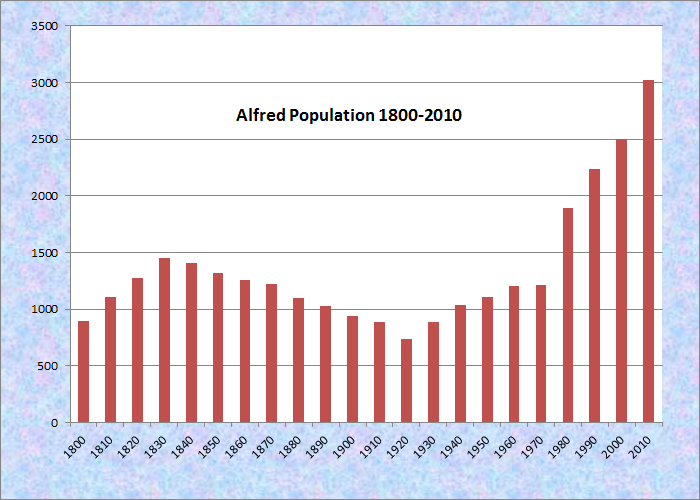
Population Trend 1800-2010
 [AL-fred] is a town in York County, incorporated on February 25, 1808.
Alfred was named for Alfred the Great, England’s Saxon King of the Ninth Century.
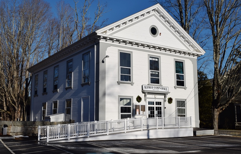
1862 Alfred Town Hall (2019)
Though Simon Coffin of Massachusetts arrived in 1764, the first permanent settlement took place in 1770.
")
Shaker Museum (2012)
 N43° 29' 59.39\" W70° 42' 59.14\"")
Museum Interior (2012) @
 N43° 30' 2.27\" W70° 42' 55.70\"")
Residence Hall, Shaker Hill (2012)
 N43° 30' 2.24\" W70° 42' 55.74\"")
Founder, Brothers of Christian Instruction (2012)
Later, a Shaker community, including Alfred Town Hall members of the Coffin family, settled on a hill overlooking what is now called Shaker Pond, a 78-acre water body in the town’s north. The “Carriage House” on the hill hosts the Shaker Museum. The Shaker community has been succeeded by a Catholic retreat campus on Shaker Hill. A statue there commemorates “J. M. Robert de la Mannais, 1780-1860, Founder of the Brothers of Christian Instruction.” Cemetery Lane leads to the resting place of Shakers, and Christian Brothers.
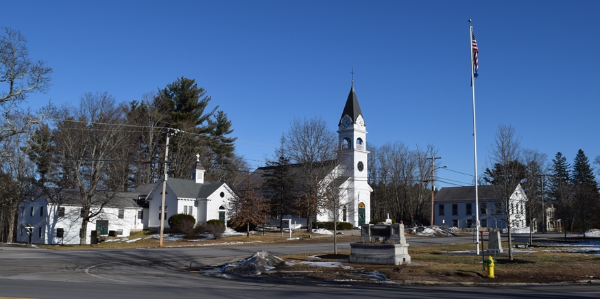
Parish Church, Village Green, Veterans Memorial, and Town Hall (2019)
")
York County Courthouse in Alfred (2003)
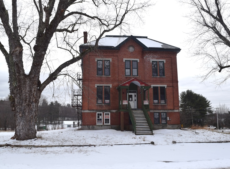
Former 1869 York County Jail
The York County seat since 1803, it was incorporated on February 4, 1794 as a district, having been part of Sanford prior to 1808.
John Holmes, who arrived in 1799, was a young lawyer specializing in real estate law, a skill in great demand in the poorly defined properties of the area.
Holmes, who became a U.S. Senator, provided the impetus for locating the York County Court House in the town of Alfred. The building was completed in 1807, in Alfred. In 1862 a jail was added to the county building complex.
")
Parsons Memorial Library in Alfred (2002)
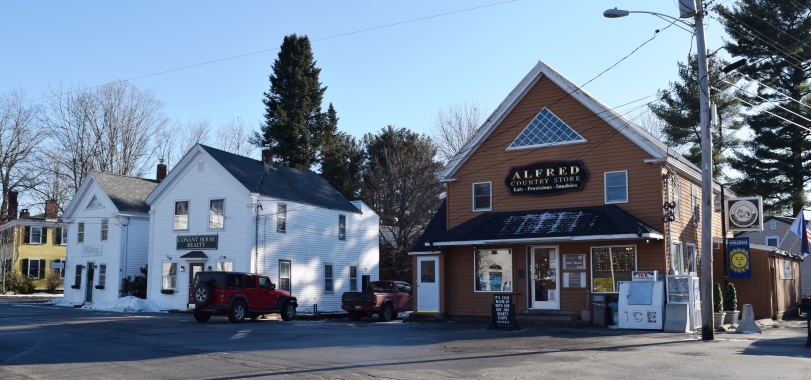
Alfred Village (2019)
Alfred set off land to Sanford on February 23, 1828 and annexed land from Waterborough (now Waterboro) on July 22, 1847.
Originally, the area was known to the Native Americans as Massabesic and was acquired from Chief Fluellin in 1661 by Major William Phipps. According to Brunelle the price was “‘two large blankets, two gallons of rum, two pounds of powder, four pounds of musket balls, 20 strings of beads’ and several other articles.”
 N43° 30' 40.39\" W70° 43' 1.16\"")
Troop A State Police (2012) @
 N43° 29' 47.92\" W70° 42' 56.74\"")
Festival Sign (2012) @
")
American Legion Post (2012)
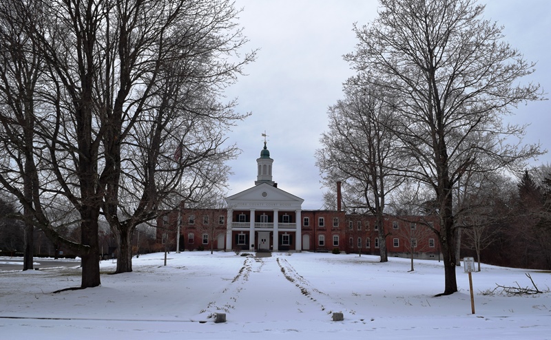
Historic York County Courthouse in Alfred (2019)
Alfred is the county seat of York County and was the site of a Civilian Conservation Corps camp in the 1930’s.
Form of Government: Town Meeting-Select Board.
Additional resources
Chadbourne, Ava Harriet. Maine Place Names and The Peopling of its Towns
Beard, Frank A. and Bette A. Smith. Maine’s Historic Places: Properties on the National Register of Historic Places. Camden, Me. Down East Books. c1982.
Boyle, Frederick R. Early Families of Alfred, Maine. Portsmouth, N.H. Peter E. Randall. 2006.
Congregational Church (Alfred, Me.). Alfred, Maine Congregational Church records vol. I & II, 1782-1866 : members, baptisms, marriages & deaths. Sanford & Springvale, Maine, Genealogical Committee Publisher 1949.
Eastman, Harland H. A Cluster of Maine Villages: Sanford and Springvale, Acton, Shapleigh and Alfred. Springvale, Me. H. H. Eastman, 1991. (Sanford, Me. Robert M. Wilson, Wilson’s Printers).
Eastman, Harland H. Alfred, Maine: the Shakers and the Village. Springvale, Me. H. H. Eastman, 1986. (Sanford, Me. Wilson’s Printers)
First Baptist Church (Alfred, Me.). Records of the First Baptist Church of Alfred, Maine, 1836-1914. Sanford and Springvale, Maine. 1935-1936. The Benapeag Chapter, DAR, 1936.
*Maine. Historic Preservation Commission. Augusta, Me. Text and photos from National Register of Historic Places: http://pdfhost.focus.nps.gov/docs/nrhp/text/xxxxxxxx.PDF and http://pdfhost.focus.nps.gov/docs/nrhp/photos/xxxxxxxx.PDF
Alfred Historic District: 83000479.PDF
Shaker Historic District: 01000371.PDF
District No. 5 School: 09000015.PDF
Senator John Holmes House: 75000117.PDF
Lord-Dane House: 92001708.PDF
Parsons, Usher. A Centennial History of Alfred, York County, Maine. Sanford, Everts & Co., Publisher. Philadelphia, Collins, printer. 1872.
National Register of Historic Places – Listings
Alfred Historic District
[Kennebunk and Saco Roads.] The historic district is located in the center of Alfred Village, which was incorporated as a municipal district February 4, 1794. The Conant and Knight families settled here during the 1760’s. They and their descendants built many of the homes and shops around the village green.
")
Alfred Town Hall in the Historic District (2002)
John Knight built a barn and ell where he entertained early travelers, earning the nickname, “Barn Knight.” During the revolutionary period, meetings to discuss the new form of government took place in the barn. Early church meetings were also held there. Across the street is the oldest home in the village center, now called “The Beehive.” Lawyers found it useful to live near the court house and the jail [see photos above] . Their affluence and pride in their homes greatly influenced the character of the village.
Alfred Shaker Historic District
[both sides of Shaker Hill Road] (See photos above.) The District contains late eighteenth, nineteenth and twentieth century buildings astride Shaker Hill Road in an historic rural landscape. With an area of about 300 acres, on a hillside that rises from about 250 feet to 470 feet, it contains fields bordered by stone walls and forests.
![1875 Carriage House [Shaker Museum] on Shaker Hill in Alfred (2012)](https://maineanencyclopedia.com/wp-content/uploads/120912056-Copy-1-620x459.jpg "1875 Carriage House [Shaker Museum] on Shaker Hill in Alfred (2012)")
1875 Carriage House [Shaker Museum] on Shaker Hill in Alfred (2012)
In 1931, the Shaker residents in Alfred moved to the Sabbathday Lake Shaker community in New Gloucester. Their lands in Alfred, Lyman and Waterboro were sold to the Brothers of Christian Instruction. Although the Brothers erected buildings on the property, they maintained the scale and siting pattern established by the Shakers. They have retained the core of the land holdings immediately surrounding the buildings, and have preserved the historic agricultural use of much of the land.*
District No. 5 School
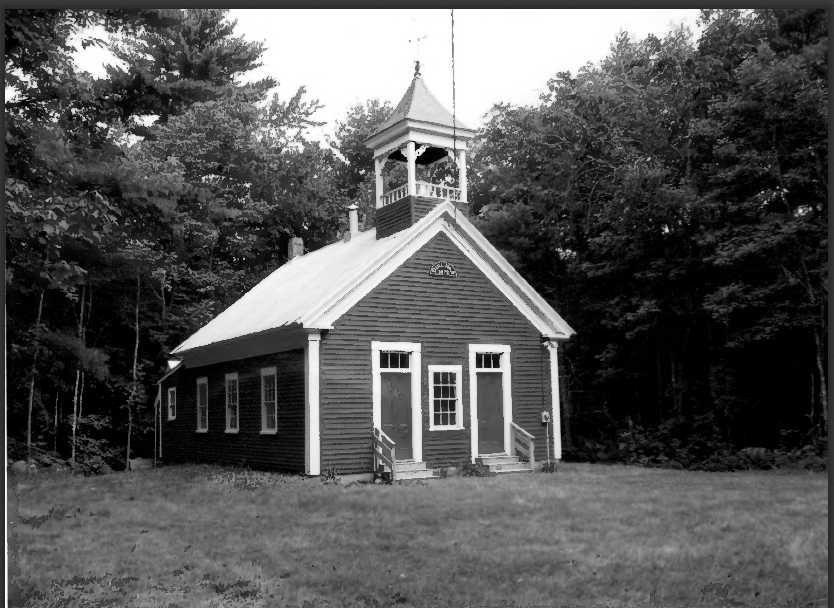
District No. 5 School Exterior
[also known as the Alfred Gore School, 781 Gore Road] Located in the village of North Alfred, the schoolhouse and woodshed/outhouse is situated on a grassy lot surrounded on three sides by stone walls at the northern edge of the village. Last used as a school in 1921, it had functioned as a residence, club house and community hall through the 1990s.
The district included the northwestern third of Alfred. After the Civil War North Alfred was a substantial village with a church, post office, store, blacksmith shop, sawmill, and later a Grange hall. In 1872 Jonathan Bean deeded land to the district. This provides the traditional date for the erection of the schoolhouse, but some evidence suggests it could have been built as early as 1856.
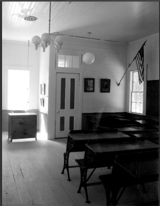
District No. 5 School Interior
It served students through the eighth grade. A wood stove provided heat; water was brought in from a spring in the summer and from a local farm in the winter. The school year was divided into three terms; spring, fall, and winter; teachers were hired by the term. The one room schoolhouse was familiar in rural Maine in the 19th and early 20th centuries. Each school district was responsible for hiring teachers and erecting and maintaining its own school.
In 1884 reformers established a town-wide school committee. In the early 20th century, the State issued guidance for the certification of teachers, and school building standards. A push to grade the schools, close schools with few or sporadic students, and transport students to schools beyond walking distance, led to the school closure in 1921. B&W Photos by Christi A. Mitchell, September 2, 2008.
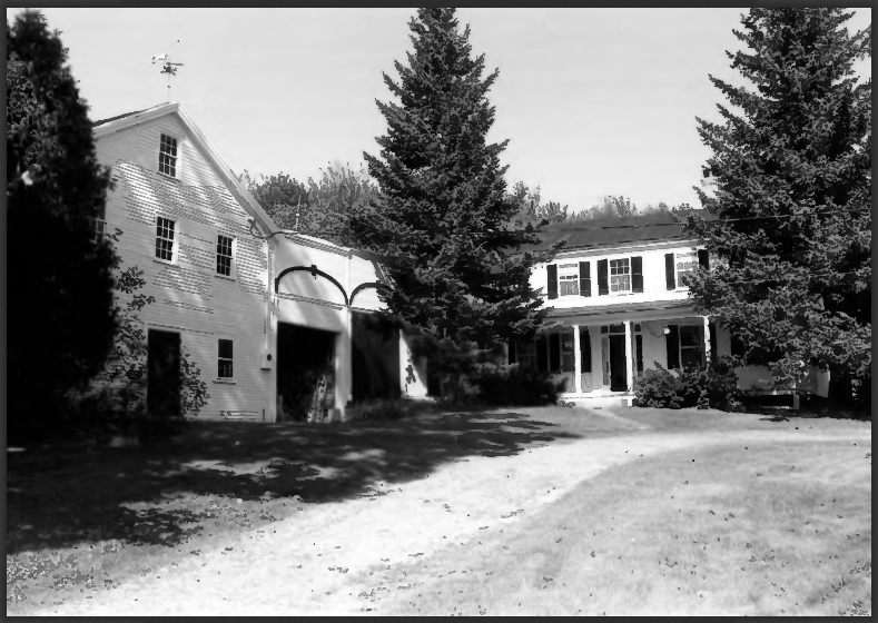
Senator John Holmes House
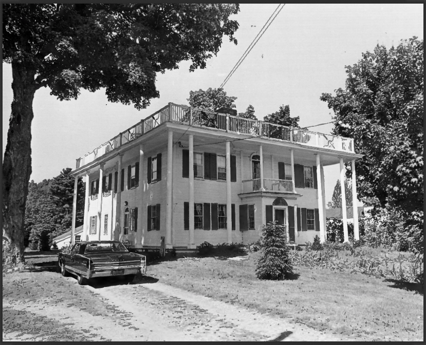
Senator John Holmes House
[US Route 202] Senator Holmes built a fifteen room mansion surrounding an enclosed court. The first story formal rooms have elaborate Federal woodwork. Other rooms reflect a more restrained treatment of period woodwork. In the front hall is a circular staircase, while the second floor hall displays a vaulted ceiling.
Holmes’ mansion of 1802 is an interesting blend, of the heavy mass of the main house with delicate ornamentation superimposed upon it. The ambitious portico and unusual bow and arrow balustrade establish the house as one of Maine’s finest examples of provincial Federal style architecture. Photo by Earle G. Shettleworth, Jr., August 14, 1974.
Lord-Dane House
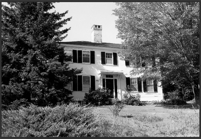
Lord-Dane House Front
[Federal Street West side, 2 miles North of junction with US Route 202] The Lord-Dane House is an early nineteenth century farmhouse which exemplifies regionally distinct architectural traits characteristic of the Federal period in York County. It was built as a rural retreat by an important shipbuilder, Tobias Lord, for his wife about 1803.
Alfred Lord-Dane Side View
The house consists of an L-shaped dwelling with an attached wing that was the carriage barn and storehouse. It overlooks Shaker Pond and the remains of Shaker Village on the opposite shore. Photos by Roger G. Reed, September, 1992.