 N44° 18' 16.99\" W70° 45' 5.55\"")
White Mountains (2013) @

Location Map for Albany
| Year | Population |
|---|---|
| 1970 | n.a. |
| 1980 | n.a. |
| 1990 | n.a. |
| 2000 | n.a. |
| 2010 | n.a. |
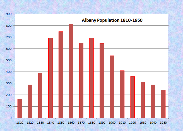
Population Trend 1810-1950
| Geographic Data | |
|---|---|
| N. Latitude | 44:18:01 |
| W. Longitude | 70:50:12 |
| Maine House | District 91 |
| Maine Senate | District 14 |
| Congress | District 2 |
| Area sq. mi. | (total) n.a. |
| Area sq. mi. | (land)n.a. |
| Population/sq.mi. | (land) n.a. |
County: Oxford
Total=land+water; Land=land only |
|
[ALL-ba-nee] an unorganized township in Oxford County, was originally incorporated as a town on June 20, 1803 from its earlier designation as Oxford Plantation. On February 18, 1811 land was set off to the town of Waterford.
It lies just south of the town of Bethel and on the edge of the scenic White Mountains National Forest in Western Maine.
A group of Andover, Massachusetts men purchased a “tract of land between Sudbury Canada [Bethel] and Waterford in 1788. It was known as Township Number Five and the Plantation of Oxford. Settled by 1784, the name Albany was adopted when the town was formed in June 1803.
Timber cutting was of major importance to the first settlers. With many rivers and streams, including the Crooked River (once proposed as an extension of the Cumberland and Oxford Canal), Albany supported several water-powered mills. In 1793, Benjamin Proctor raised a grist mill in the southern part of town. Later acquired by John Lynch, the mill’s immediate surroundings quickly took on the name “Lynch’s Mills” and later, “Lynchville.”
During the second half of the nineteenth century, farming was a major occupation. In the twentieth century, several once-prosperous farmsteads were the scene of active mining operations, mainly for feldspar, quartz, and beryl. By the late 1980s little remained beyond a few scattered farms and the three public buildings near the junction of Routes 5 and 35.*
According to George Varney’s 1886 Gazetteer,
The manufactures consist of lumber, shingles, staves, boxes, spools, boots, and shoes. Albany post office is about 8 miles south of Bethel Hill, on the Grand Trunk Railway, which is the nearest railway station. The soil of the town is of fair quality. The principal crop for the market is hay.
This town is the birth-place of Rev. Asa Cummings, D. D., for many years the able editor of the “Christian Mirror,” the organ of the Congregationalists in Maine. The churches in town at a Congregationalist and a Methodist. Albany has ten schoolhouses . . . .
In the 1920s and 1930s the White Mountains National Forest expanded to include all the land in Albany west of Route 5 (north of the Town House) and Route 5/35 (south of the Town House). Almost forty percent of the town’s land was removed from its tax base.
On November 20, 1937, with a declining population, it surrendered its organized status, thus ending its township population count by 1950. However, three of its vintage community buildings remain in good condition.
The 1848 Town House, listed on the National Register of Historic Places, is near Maine routes 5 and 15. According to the Maine Historic Preservation Commission’s Christi Mitchell, this Greek Revival building, while modest, was intended to mimic the Acropolis and link the town to Greek democracy.
 N44° 21' 5.04\" W70° 47' 25.80\"")
Songo Pond from Songo Pond Road (2013) @
Albany Township could be the “Ponds Champion” of Maine with Broken Bridge, Chalk, Crocker, Hutchinson, Kneeland, Little Papoose, Mosquito, Proctor, Round, and Songo. Albany Brook trail in the White Mountain National Forest is a one-mile hike to Round Pond from Crocker Pond Campground.
The Congregational Church and the nearby Mountain Grange still stand. As the Lewiston Sun Journal noted in 1975,
Mountain Grange . . . and the Albany Congregational Church are the centers of activity for the township of Albany. They stand on a sightly elevated location at Hunt’s Corner overlooking the White Mountains and the Mahoosuc Range.
 N44° 19' 26.62\" W70° 46' 9.37\"")
Albany Town House (2013) @
 @ (2013) N44° 18' 6.16\" W70° 44' 54.41\"")
Congregational Church (’13) @
 @ (2013) N44° 18' 6.36\" W70° 44' 53.89\"")
Mountain Grange (2013) @
National Register of Historic Places – Listings
Albany Town House
[Maine Route 5/35, Albany Township]
The Town House is one of only three historic public buildings in the township. It was built in 1848 by the residents of Albany for use as a polling place, town meeting site, and the location of governmental activities.
")
Albany Town House Interior (2007)
Architecturally, it is a common structure with just a nod towards the Greek Revival style. After the town was deorganized, the building gained a sign renaming it the Albany Town Hall, and it continues to provide the community with a meeting and gathering space, as well as serving as the only voting place in town. Importantly, it is the only existing, local reminder of the community’s existence as the Town of Albany between 1803 and 1937.
In 1947 the building was purchased by the Albany Improvement Association, and since then it has continued to provide the community with a meeting and gathering space, as well as serving as the only polling place in town.
[Christi A. Mitchell photo]
Additional resources
* This historical account has been condensed and edited from Bennett, Randall. Oxford County. Maine: A Guide to Its Historic Architecture. (Bethel: Oxford County Historic Resource Survey), 1984, quoted in the Maine Historic Preservation Commission’s document cited below.
Adams, Eileen M.”Town Hall named to historic list. Lewiston Sun Journal. September 4, 2007. pp B1, B5.
Holt, Edward A. A History of Sawin Hill Road in Waterford and Albany, Maine. Harpswell, Me. E.A. Holt. 2007.
Labbie, Edith. “Albany Is Typical Maine Community.” Lewiston Journal. August 9, 1975.
Maine. Historic Preservation Commission. “Albany Town House.” Augusta, Me. June 20, 2007. National Register of Historic Places: http://pdfhost.focus.nps.gov/docs/nrhp/text/07000793.PDF. Interior photo by Christi Mitchell. http://pdfhost.focus.nps.gov/docs/nrhp/photos/07000793.PDF.
Varney, George J. A Gazetteer of the State of Maine. 1886. p. 66.
The captions for the Grange and the Church are reversed at this website. I’ve lived at 18 Picnic Hill Road for 14 years and am sure about this. FWIW.
Thank you Mr. Sturtz! You are correct, of course. Corrections have been made.
I appreciate your taking the time to point out the error.
Was the town house ever a schoolhouse?