")
Historic 1884 Lincoln One-Room School Interior (2014)

Location Map for Acton
| Year | Population |
|---|---|
| 1970 | 697 |
| 1980 | 1,228 |
| 1990 | 1,727 |
| 2000 | 2,145 |
| 2010 | 2,447 |
| Geographic Data | |
|---|---|
| N. Latitude | 43:32:01 |
| W. Longitude | 70:52:57 |
| Maine House | District 20 |
| Maine Senate | District 34 |
| Congress | District 1 |
| Area sq. mi. | (total) 41.1 |
| Area sq. mi. | (land) 37.7 |
| Population/sq.mi. | (land) 64.9 |
| County: YorkTotal=land+water; Land=land only | |
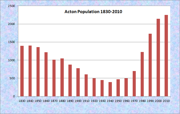
Population Trend 1830-2010
") [AK-tun] is a town in York County, incorporated on March 6, 1830 from a portion of Shapleigh.
[AK-tun] is a town in York County, incorporated on March 6, 1830 from a portion of Shapleigh.
It ceded some land back to Shapleigh in 1831.
It was part of a much larger tract of land purchased in 1661 by Francis Small from Chief Sunday of the Newichawannock Tribe.
Settled in 1776, the town’s first mill, a grist mill, was built on the Salmon Falls River in 1779 by Joseph Parsons.
Prior to incorporation it was the western part of the plantation of Hubbardstown; in 1789 it became the eastern part of Shapleigh.
The town was named for Acton, Massachusetts, which was named for Acton, England, part of greater London.
Acton includes the main village of Acton in the north central area of the township. The villages of Miller Corner and South Acton are to the south.
")
Shipping Apples (c. 1940)
")
Apple Farm in Acton (2012)
Apples have been a significant crop for this western Maine community, though the number of active orchards has declined in recent years.
Silver was discovered in 1877, followed by a decade of mining and prospecting, after which the mines were abandoned.
Beginning in 1850, the town’s population began a century of decline, reaching its lowest point in 1940.
As have several small communities in York County, Acton has shown significant population growth in recent years.
The number of permanent residents has more than tripled since 1970, and doubled since 1980 when its population was the highest it had been in 120 years.
2010 U.S.Census figures confirm that the trend continues.
 N43° 30' 19.92\" W70° 54' 3.05\"")
1841 Baptist Church, (2014) @
 N43° 30' 50.47\" W70° 52' 22.79\"")
Acton Fairgrounds (2014) @
")
Public Safety Building (2014)
")
Elementary School (2014)
 N43° 31' 55.47\" W70° 54' 32.65\"")
Municipal Buildings (2014) @
Nestled on a small hillside near Route 109 and H Road are the town’s library, town hall, and 1781 Congregational Church. Two veterans memorials lie nearby. Acton’s western border is with New Hampshire and is defined by the Salmon Falls River.
It has substantial frontage on several lakes: Mousam, Wilson, Great East, and Square Pond.
 N43° 31' 57.97\" W70° 54' 32.66\"")
World Wars I & II Veterans Memorial (2014)
")
Korean & Vietnam Wars Veterans Memorial (‘The town lies southwest of Sanford on U.S. Route 202 and Route 11, which continue into New Hampshire.
")
Convenience Store On Rt. 109 (2014)
")
Mousam Lake on Rt. 109 (2014)
Form of Government: Town Meeting-Select Board.
Additional resources
Chadbourne, Ava Harriet. Maine Place Names and The Peopling of its Towns.
Treadwell, Olive M. Sesquicentennial History of Acton, Maine 1830-1980. Town of Acton. 198?.
Goodwin, Esther E. Acton and Shapleigh, Maine – Past & Present. Shapleigh, Me. Acton-Shapleigh Historical Society. 1976.
Fullonton, Joseph. The History of Acton, Me. Dover, N.H. W. Burr, printer. 1847.
*Maine. Historic Preservation Commission. Augusta, Me. Text from http://www.maine.gov/tools/whatsnew/index.php?topic=mhpc_recent_listings&id=522080&v=article.
Petersen, Debbie. Shapleigh and Acton. Charleston, SC. Arcadia Publishing. 2010.
National Register of Historic Places – Listings
Photos, and edited text are from nominations to the National Register of Historic Places researched by Maine. Historic Preservation Commission. Full text and photos are at https://npgallery.nps.gov/nrhp
Lincoln School
 N43° 29' 29.53\" W70° 54' 39.64\"")
1884 Lincoln One-Room School (2014)
[8 Orchard Road] The Lincoln School is a one-story, one-room schoolhouse located in the southern portion of the town of Acton. Set in a rural, agricultural area at the intersection of two long-established roads, the school was built in 1884 to serve the students of District # 2, one of 14 districts that had been established in Acton in the19th century.
This small school survived the first decades of 20th century consolidation and continued to educate students until 1957, when a multi-grade elementary school was built for the entire town. The Lincoln School was listed in the National Register for its association with patterns of rural schooling in 19th- and 20th-century Maine, and as a good example of a type of educational facility that was once common throughout the state.
Photos taken 2014 at N43° 29′ 29.53″ W70° 54′ 39.64″.